https://daahl.ucsd.edu/DAAHL/
From the site:
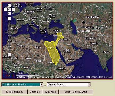 DAAHL's Google Maps interface for Empires
Click the "Empires" link above to open this page.
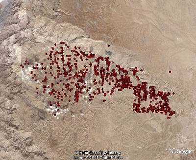 Archaeological sites in Wadi Hasa, Jordan,
plotted with DAAHL's database and Google Earth.
Click the "Search Database" link above to open this page.
From the site:
What is the Digital Archaeological Atlas of the Holy Land?
DAAHL's Google Maps interface for EmpiresClick the "Empires" link above to open this page.
The
Digital Archaeological Atlas of the Holy Land (DAAHL) is an
international project that brings together experts in information
technology including Geographic Information Systems (GIS) and the
archaeology of the Holy Land (modern Israel, Palestine, Jordan, southern
Lebanon, Syria and the Sinai Peninsula) to create the first on-line
digital atlas of the region held sacred to the three great monotheistic
faiths - Judaism, Christianity and Islam. Using the power of spatial
information systems such as Google Maps and Google Earth, GIS, the tens
of thousands of recorded archaeological sites for the region - from the
remote prehistoric periods to the early 20th century - will be entered
into a comprehensive database along with site maps, photographs and
artifacts. The historical and archaeological content for this project
will be developed by a team of over 30 international scholars working in
the region, helping to provide the data used to create the Atlas. This
website and its content will serve as the prototype "knowledge node" of
a more comprehensive Digital Archaeological Atlas Network for the
Mediterranean region.
Archaeological sites in Wadi Hasa, Jordan,plotted with DAAHL's database and Google Earth.
Click the "Search Database" link above to open this page.
New
developments in telecommunications and information technology are
revolutionizing the fields of archaeology, history, and the social
sciences. The atlas represents a signature project of the Center for
the Interdisciplinary Study of Art, Architecture and Archaeology (CISA3)
at the University of California, San Diego and the Geo-Archaeological
Information Applications (GAIA) Lab at Arizona State University. The
atlas project brings together many of these advances based on new
discoveries and the latest content concerning one of the most
politically complex but meaningful geographic regions in world heritage.
The control of time and space allow archaeologists to uncover address
the 'big questions' of human history and social evolution. These
include answering how and why the major technological revolutions of
history occurred and influenced social and historical change in the
Middle East. In broad strokes, the control of time and space are
essential commodities in the construction of a heritage-based
cyberinfrastructure, which come together for scholars and the general
public in the DAAHL. New developments in GIS, high-precision
radiometric dating methods, and archaeological fieldwork carried out in
the Holy Land (Israel, Jordan, Palestine, Lebanon, southern Syria and
the Sinai Peninsula) have helped identify significant "Global Moments"
of fundamental social change in this region. The atlas will harvest,
analyze and disseminate settlement pattern and new archaeological data
for each key period of culture change in the Holy Land, from the Lower
Paleolithic over 2 million years ago to the early 20th century when the
region came under British control.
This prototype web site is organized around two central themes, a
series of case studies, historic maps, and database search functions.
The "Empires" theme organizes information that illustrates the march of
empires across the Middle East, from the development of the first
Egyptian state in about 3000 BCE to the Ottoman Empire in 1918 CE.
Here, the DAAHL concentrates on the impact of imperial "ordering
templates" upon the lifeways of indigenous peoples in the region, as
they are reflected and refracted by imperial and local traditions. The
DAAHL website incorporates an interactive Google Maps interface, which
can be animated to show the spatial footprints of more than 20 empires.
A drop-down list lets the user select any of the empires; a selection
automatically loads text in the right side of the page that introduces
the empire, and queries the DAAHL database to present the archaeological
sites in the database that were contemporary with the chosen empire.
(The user must be zoomed in about halfway to see the site points). Each
site point can be clicked to open a balloon with its name, and the name
can be clicked to open a page in the atlas that contains three groups
of information: 1) the listing from the DAAHL database, showing all the
filled-in fields from the site table; 2) a listing of all the chapters
or case studies in the DAAHL website that discuss the project; 3) a
detailed, verbal description of the site, which can be richly embedded
with pictures, tables, and static maps.